Prehistory of the Gulf and Arabian Seas
Ancient Arabia
and the Pre-Islamic or Jahiliyya Era.
A
great amount of knowledge has been gained from the archaeological research of
ancient Yemen, where the South Arabian kingdoms excelled in water management
and agricultural development. With their
construction of large dams, they were able to harness agricultural development
and commercial trade centered around a system of royal dynasties that arose in
the 1st millennium B.C.E. Modern
archaeology has contributed a wealth of knowledge about the material and
economic life of Ancient Arabia and its achievement in establishing towns,
agriculture and a system of trade.
Within the vicinity of the Arab Gulf, the great finds of Dilmun
civilization in the area of Bahrain, and of ancient Magan in the area of the
UAE and the Oman peninsula provide us with evidence of the oldest settlements
in our area.
_burial_chambers_at_Saar%2C_Bahrain.JPG) |
| Figure 1 Dilmun archaeological site in Bahrain (Source Wikipedia) |
The
work of D.T. Potts is influential including the following works, The Arabian Gulf in Antiquity (Potts, The Arabian Gulf in
Antiquity, 1990) ;
Ancient Magan: The Secrets of Tell
Abraq (Potts, 2000) ; and In the Land of the Emirates: The Archaeology and History of the UAE (Potts, 2012) . A broader survey of the ancient and
pre-Islamic history of the entire Arabian Peninsula and the Arabian people at
large as they moved into the region of the Mediterranean and Mesopotamia, is
found in Arabia and the Arabs: from
the Bronze Age to the Coming of Islam (Hoyland, 2001) and Volume 1 of The New Cambridge
History of Islam (Robinson, 2010) .
Defining Arabia in Geographical Terms. Arabia is generally defined as the land mass
known as the Arabian peninsula and extending into the Syrian desert to the
north. It is an area distinguished by
the phenomenon of the 200 mm/year rainfall line where agriculture is limited
and practiced only through measures of extensive catchment basins and other
techniques needed to supplement the low rainfall (Hoyland, 2001, p. 4) . Arabia is divided into four distinctive
regions: The western highlands, that run
along the length of the Red Sea, and which reach a height of 3600 meters in the
south. This includes the Hijaz and the
key centers of Mecca and Medina. The
vast interior known as the Rub` al-Khali (Empty Quarter), the Nafud and Dahna
deserts of the center, and the Hisma, Hamad and Syrian deserts of the
north. The most famous region of
Arabian antiquity is in far South in Yemen, where its ancient Sabaan kingdoms
were rich with mineral and agricultural wealth derived from elaborate dam
systems and irrigation. The fourth
region is ours, the low lying Eastern coastal lands of the Arabian Gulf, with
hot and humid summers, broken up by the rock formations and palm laden oases
and uplands of the Najd and Oman. Eastern Arabia of the Stone Age and Iron Age Stone Age tools have been found in the
interior of Sharjah that date from about 125,000 to 90,000 BCE. Considerable evidence of Iron Age settlements
in the UAE and Oman date from about 1300-900 BCE. As sea levels were considerably
lower, humans probably could crosss relatively easily across parts of the Red
Sea trough from Africa into Arabia (Potts, 2012,
p. 17) .
Climate change over the next 100,000 years left the area more arid and may have
forced these early settlers to move on.
From the Neolithic or and early Holocene Period, evidence of flints and
arrowheads from around 8,500 – 7,500 BCE have been found at Jebel Faya. The first evidence of actual settlements,
with remains of housing, burial sites, and the use of decorative jewelry, date from around the 7th and 6th
centuries BCE. The oldest archaeological
sites, dating from around 7,000 years are on the island of Marawah, where we
also find much later staone age prehistoric oval buildings. More importantly at a site known as BHS 18 in
the interior of Sharjah at the foot of Jebel Buhais, archaeologists have
uncovered elaborate painted jars of an imported Ubaid type of pottery
recognized and found in Mesopotamia (Potts, 2012, pp. 26-28) . At the BHS 18 site which was occupied for
about 500 years a survey of human skulls revealed that 7.2 percent of all
skulls examined had head injuries, probably from warfare or other struggles,
and there was evidence that ancients performed open skull surgery on these
wounds. From around 3200-2700 BCE we
find evidence of round monumental tomb, known as the Hafti type at Jebel Hafit.
 |
| Map from Michael Rice, The Archaeology of the The Arabian Gulf |
In
the Iron Age, the best preserved and largest of these are found at the
settlements and large round tomb monuments in the oasis at Al Ain. These sites are known as Hili 2 and Hili 14
and date from around 1300-400 BCE. Other
sites in the area of Ras al-Khaimah and elsewhere show other settlements and
stone tomb formations and at Rumeilah collections of decorative ceramic and
carved stone pottery have been found (Potts, 1990,
p. 381) .
We also have evidence of considerable metallurgy and working of iron and other
metal tools, swords and other weapons, iron arrowheads, jewelry and hoes for
farming. Go to the UNESCO World Heritage Site to explore
further these archaeological sites in the UAE (UNESCO, 2014) .
Dilmun and Magan Civilization: Archaeology and new sites found in the United Arab Emirates
Among the impressive early sites showing developments of water engineering and town building are the following:
In the Iron Age settlement at Muweilah in Sharjah, United Arab Emirates, the following site from about 900-800 BCE has been excavated and studied. Iron Age technology in the region is generally dated from about 1300-300 BCE and featured the falaj (pl. Aflaj) irrigation systems that allowed channeling of underground water resources from mountains down into the new settlements.

http://universes-in-universe.org/eng/art_destinations/sharjah/archaeological_sites/muweilah
Dilmun and Magan Civilization: Archaeology and new sites found in the United Arab Emirates
 |
| Map from Michael Rice, The Archaeology of the The Arabian Gulf |
In the Iron Age settlement at Muweilah in Sharjah, United Arab Emirates, the following site from about 900-800 BCE has been excavated and studied. Iron Age technology in the region is generally dated from about 1300-300 BCE and featured the falaj (pl. Aflaj) irrigation systems that allowed channeling of underground water resources from mountains down into the new settlements.
http://universes-in-universe.org/eng/art_destinations/sharjah/archaeological_sites/muweilah
Classical Yemen and the Rise of the Sabaean Kingdom as an Agrarian and Trading State circa 1200 BCE to 250 CE
The Great Dam of Marib was among the ancient world's greatest engineering feats. It was constructed during the Sabaean Kingdom that ruled between about 1250 BCE to 250 CE, that is about 1,000 years. During this time the fabled Queen of Sheba reigned. The kingdom was a trading state that made use of the verdant pockets of terraced lands watered by the irrigation from the large water engineering projects such as the Great Dam of Marib. The Great Dam was probably started in around 800 BCE and survived in some form until about the 6th century CE when it was breached or collapsed due to either earthquakes or lack of maintenance.
This kingdom and its agricultural wealth is famously mentioned in the Quran: As-Sabah 34:15-16
لَقَدْ كَانَ لِسَبَإٍ فِي مَسْكَنِهِمْ آيَةٌ ۖ جَنَّتَانِ عَن يَمِينٍ وَشِمَالٍ ۖ كُلُوا مِن رِّزْقِ رَبِّكُمْ وَاشْكُرُوا لَهُ ۚ بَلْدَةٌ طَيِّبَةٌ وَرَبٌّ غَفُورٌ
SAHIH INTERNATIONAL
There was for [the tribe of] Saba' in their dwelling place a sign: two [fields of] gardens on the right and on the left. [They were told], "Eat from the provisions of your Lord and be grateful to Him. A good land [have you], and a forgiving Lord."
فَأَعْرَضُوا فَأَرْسَلْنَا عَلَيْهِمْ سَيْلَ الْعَرِمِ وَبَدَّلْنَاهُم بِجَنَّتَيْهِمْ جَنَّتَيْنِ ذَوَاتَيْ أُكُلٍ خَمْطٍ وَأَثْلٍ وَشَيْءٍ مِّن سِدْرٍ قَلِيلٍ
SAHIH INTERNATIONAL
But they turned away [refusing], so We sent upon them the flood of the dam, and We replaced their two [fields of] gardens with gardens of bitter fruit, tamarisks and something of sparse lote trees.
 |
| Ruins of the Great Dam of Marib in Yemen (Source Wikipedia) |
Arabia in
Classical Antiquity 500 BCE to 600 AD
In
the centuries preceding the arrival of Islam parts of Arabia came under control
or influence of the Roman empire and its successors, the Byzantine Empire and
Sassanid Dynasty. Arabia at the time was
a mixture of cultural influences, that had indigenous local religious beliefs,
as well as Jews and Christians. The
ancient city of Palmyra, located at an oasis in the interior of Syria,
represents the Roman attempt at dominating the interior trade between the
Eastern Mediterranean, the Levant, and the area of Iraq where the Sassanid
Empire was a rival to Roman rule in the region (Gates, 2011, p. 400) . As the Roman power
weakened from the 3rd century onward from the Sassanid attacks
against them, Palmyra became an independent trade city-state that adapted local
traditions for a brief period, and had its own cult religion based around the
Semitic gods Maduk and Balil (Gates, 2011, p. 400) . However Palmyra’s distance and limited sustainability
left it vulnerable to attack and it was mostly abandoned by the end of the
Roman period in the 4th century.
Thereafter it remained as a very small and limited settlement up through the Ottoman
period when it was finally deserted.
.jpg/1024px-Palmyra_theater02(js).jpg) |
| Figure Palmyra (Source Wikipedia) |
Go
to the following website and explore the following websites on Palymra: Palmyra
in 360 degrees. http://www.kaemena360.com/360/PalmyraTour/ Metropolitan Museum of Art Heilbrunn Timeline
http://www.metmuseum.org/TOAH/hd/palm/hd_palm.htm Palmyra excavations: Palmira. Missione
Archeologica Italo-Siriana. http://users.unimi.it/progettopalmira/index.html (in Italian,
with some English)
Study
Guide Questions: Describe the city plan and main buildings
of Palmyra. To what extent do they show a mix of Roman and local Syrian
influences? The Byzantine Empire
relied on Greek both as an administrative language and as a language for its
form of Christianity and ruled from its capital base in Constantinople. The
Byzantine Empire retained a great deal of the administrative organization of
the Roman Empire of which it was the Eastern part. The Sassanid Dynasty relied on a form of
the Persian language and was based at the city of Ctesiphon in central Iraq and
held influence over Iran and parts of Iraq, where its religious beliefs were a
combination of Zoroastrian, and
Christian beliefs in a society ruled by kingship (Hourani,
2002, p. 9) . The Arabian peninsula found itself at the
crossroads of these two empires and managed a trade system between them and
Arabian cities and African kingdoms that extended down the Red Sea into
Ethiopia and East Africa. A number of
pre-Islamic city states, including Petra in Jordan, were built up and
maintained as trading agents along the routes of this long distance trade that
brought valuable minerals, spice and agricultural products northward to the
Byzantine and Sassanid Empires (Gates, 2011) .
Petra
is an interesting and useful city to study as evidence of the northward spread
of Arabian culture in pre-Islamic times.
The structure of the carved monuments and structures into the cliff
walls began around 312 AD, during the late Roman Empire. The Nabateans who ruled in this region built
a trade kingdom based on long distance trade between Arabia and the Eastern
Mediterranean. The Nabateans originally
worshipped ancient various Ancient Arabian gods or idols, until Petra came
under influence of Byzantine Christianity and then later converted to Islam in
the 7th century.
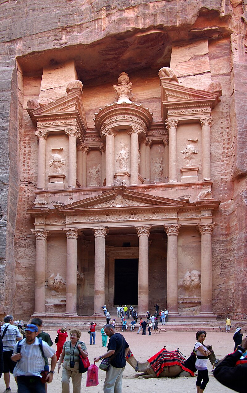 |
| Figure 4 The Treasury at Petra (Source Wikipedia) |
The
following websites provide guides to Petra:
There is a 3D panorama of
Petra
or for a summary of archaeological research Brown University has a web page on
their archaeological
projects at Petra
(Joukowsky, 2007)
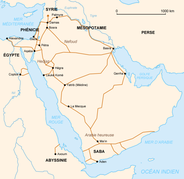
Figure 5 Map of
Pre-Islamic Arabian trade routes

Figure 6 Map of Main
Tribes of Pre-Islamic Arabia.
Source: Wikipedia
Pre-Islamic society in Arabia was characterized by the varying degree of tribal alliances. Certain tribes based around the trade centers of Mecca and Medina were held together by their commercial and family ties. This included the Quraysh tribe. Others were more dispersed and probably included elements of Bedouin society. These kinds of tribes included the al-Tamimi family and tribes. It seems that when Arab settlements found common needs, they may have found it convenient to trace their lineage to a common ancestor, and accordingly adopted a useful common name, like al-Tamimi